Understanding and Protecting the Sites
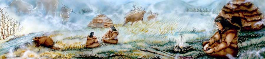
Revealing one of the largest Palaeoindian sites in North America at the time, the excavations of the original Debert site in the 1960s identified numerous features, such as fire pits (also called hearths), with large quantities of artifacts. The artifacts showed evidence of hunting, hide processing, bone and wood working, as well as more general tasks. Importantly, the excavations also employed a range of “ologists,” including geologists and soil scientists, not just archaeologists. This interdisciplinary approach to understanding the sites has continued to the present. Remarkably, the excavations and research that happened at the original Debert site continue to anchor the understanding of other sites of this age throughout northeastern North America.
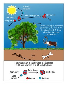
What About
Those Dates?
In 1989, additional sites were discovered by staff of the Nova Scotia Department of Natural Resources and tested further by Stephen Davis of Saint Mary’s University. These sites, called the Belmont sites, were smaller than the original Debert site with fewer artifacts, but the Belmont sites were also more numerous and helped to define a complex of sites.
For more than a decade the Mi’kmaw Nation has taken the lead in protecting the Debert sites. In partnership with Provincial and Federal departments and agencies, the Nation has undertaken cleaning, buffering, and identifying sites in order to protect them. This work has identified new sites in the Debert area, increasing the total number to more than twelve, and protected unknown sites in the Debert area from destruction through new provincial regulations.
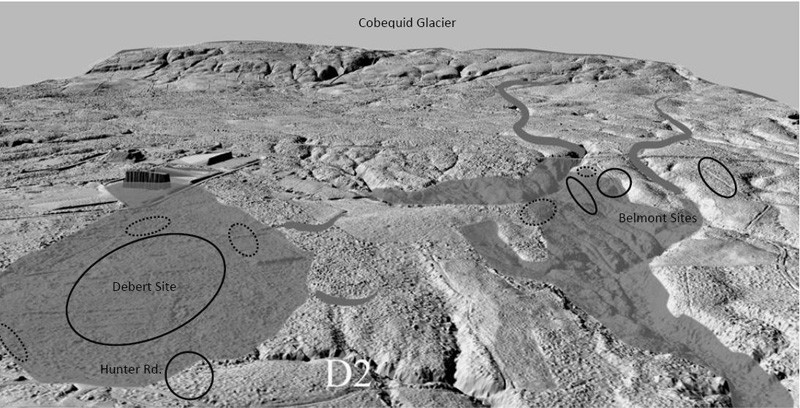
Digital Elevation Model (DEM) showing sites in relationship to glacial deposits. LIDAR base image courtesy of Tim Webster, Centre of Geographic Sciences, Lawrencetown, Nova Scotia. Base map data courtesy of Tim Webster, Applied Geomatics Research Group, Nova Scotia Community College, Middleton, NS.


 sharing our stories
Leave a Reply