")
The current undertaking to have the Cliffs of Fundy in northern Nova Scotia designated an official UNESCO Global Geopark is a first for any such initiative in Canada.
UNESCO Global Geoparks are about linking people to their landscape through geology and history, and applications are a community — not government — initiative. The steering committee for the aspiring Global Geopark from the outset has included input from the Mi’kmaq community to depict the Indigenous history of the area.
To date there are only two official Global Geoparks in Canada: Tumbler Ridge in eastern British Columbia and Stonehammer in southern New Brunswick.
The shores of the Cliffs of Fundy stretch from Economy in the south to Apple River in the north and are especially significant to the Mi’kmaq people. They are heavily entwined in their spiritual and cultural stories of Glooscap (Kluscap), whose life and lore include Glooscap’s deep respect for his grandmother and his profound love for his people and land.
Xavier Le Guyader, program officer with the Canadian Commission to UNESCO, believes Global Geoparks can play a key role in the current reconciliation process in Canada.
“The geoparks can work closely with their Indigenous partners to promote the culture, history and traditional knowledge of the Indigenous peoples who live or have lived in the designated site.”
Artist and cultural educator Gerald Gloade of Millbrook has worked closely with the steering committee in developing their application to the Canadian Commission of UNESCO, which will make the ultimate decision on the aspiring geopark. He notes that the Mi’kmaq belief in “two-eyed seeing” is basically the way Aboriginals view the natural world and how it is confirmed by modern science.
The Cobequid geological fault line runs across the north of Mi’kma’ki (which includes all of Newfoundland, Nova Scotia, Prince Edward Island, the Gaspe Peninsula in Quebec, and Northern Maine), and the Minas Basin geofracture runs across the bottom, “so what we are talking about (in the geopark) is unique material created in unique places under unique conditions,” says Gloade.
“There’s a very close, intimate relationship to this area and to the material produced from this area, and it tells a big part of our story — how we survived here for thousands of years. It’s not just a story that happened someplace. When you tell a story about how Glooscap made an amethyst necklace for his grandmother on Partridge Island, you go to Partridge Island and you find amethyst.
“About 6,000 years ago,” says Gloade, “there was a shift in the platelets in the Bay of Fundy. With this plate shifting, (the beach) popped up 150 feet from where it was. When you’re on the top (of the cliff) you’re seeing the beach sand, the plants and the vegetation, which is actually shoreline vegetation.
“There are shorebirds 150 feet in the air, not on the shore. Our ancestors have been here for 13,000 years so that means we were here the day those tectonic plates popped.”
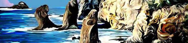
Gloade tells the story of the Three Sisters as depicted in one of his paintings, a part of Glooscap legend. It is of a rock formation at Cape Chignecto where three sisters hiding in the woods were said to have played a trick on Glooscap when he was hunting moose. When Glooscap discovered their trickery he punished them by turning them to stone, where they remain today.
“The head of a moose swimming across the Bay is what is now called Isle Haute,” says Gloade.
The Mi’kmaq ecological calendar, which dictates events the Mi’kmaq people participate in at certain times of the year, is also of great cultural significance, says Gloade.
“Each one of the moon periods is based on something that goes on in the environment at that time of year. This cycle of life wasn’t created to serve you; it’s like you’re part of it.”
Water is also extremely important to the Mi’kmaq.
“We do not enter the water for recreational purposes until the waters have been shocked (by lightning) in the month of July,” says Gloade. “May and June are plenty warm to go swimming, plenty warm to get in the waters but it’s not our turn. In May and June, the waters are being used by the insects, reptiles, amphibians and fish. That’s part of that ecological calendar and, of course, the waters in the bay are basically the renewal of life every year.”
Says Le Guyader, “One of the common values that can be shared on geoparks between Indigenous and non-Indigenous communities is the respect of the land, which represents a key element to start a conversation between the two communities. This complementary vision enriches the scientific explanations of the geological heritage that is the subject of the designation.”
 sharing our stories
I love your art!!
Thank you, this is by our talented colleague, Gerald Gloade!
The GeoPark is a fabulous project!!
Unifying instead of dividing.
As a N.S. based tour operator, presenting a glimpse of the huge History of the Mi’kmaw and the indescribable richness of our geological past, I can only be grateful to the people behind this nation-wide (and international) initiative.
How can one help, personally and/or professionally?
R.L.